
Utility infrastructure in the US is aging. Most water and energy assets currently in use have been in place for more than forty years. This comes with downsides: more frequent breakdowns, soaring repair costs, and even the risk of major disasters. But full replacement isn’t the only solution. The trick is better monitoring. That’s where drone utility inspection and mapping are helpful.
Drones are a fast, accurate, and cost-friendly way to amass data from assets and keep them in check. They’re a real help for utility companies grappling with dangerous, complicated, or large areas.
In this article, we’ll delve into the capabilities of drones and pinpoint three major ways in which they are put to work. So, let’s get started!
What Can Utility Drones Do?
In essence, drones offer utility companies a valuable bird’s-eye view of their assets. They can collect data in areas that are dangerous or even inaccessible to workers. For instance, drones can easily survey power lines, sewer systems, and water towers.
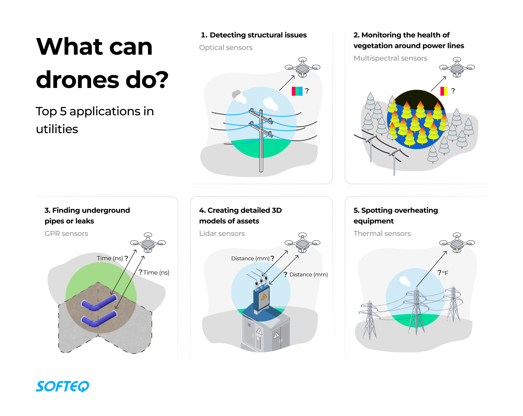
Drones can be fitted with different sensors depending on the job. Here’s a quick look at a few:
- Optical sensors snap high-resolution photos and record videos, just like a regular camera. They offer a full picture of a utility company’s infrastructure, pinpointing where each asset sits. In addition, they spot hard-to-see structural issues such as rust and cracks. This enables utility companies to kickstart maintenance and repairs proactively.
- Lidar sensors use pulsed laser light to measure the distance to an object. They are also used to create detailed 3D models of things like power lines and poles. This lets you check their condition and spot risks, like drooping lines or overgrown plants. They also help model the surrounding terrain, which is handy for planning and risk evaluation.
- Thermal sensors use infrared tech to identify temperature variations on different surfaces. They turn heat into visible images, or thermograms. This offers utility companies a handy way to spot overheating equipment. And that’s not all—these sensors can also detect leaks in hot water or steam pipes.
- Multispectral sensors take in more than just the common red, green, and blue color bands visible to humans. This enables utility companies to keep an eye on the health of vegetation growing near power lines. The sensors record how different plants reflect light at varying wavelengths, identifying fast-growing or unhealthy vegetation that could become hazardous to power lines.
- Ground-penetrating radar (GPR) sends radio waves into the ground and measures their strength upon returning along with any delay. Changes in the return signal can reveal buried utilities or structures. Water companies often use GPR to locate underground pipes or leaks. It can map out subterranean infrastructure to avoid mishaps during maintenance. What’s more, it can also spot soil saturation areas that might point to a leak or blockage.
Once the drones have done their job, the data they have collected heads off to processing software. This software can piece together many images to form a detailed 2D map and locate hotspots that might spell trouble. It can also create highly accurate 3D models of the environment, which is handy when it comes to planning and simulations.
Drones in the utility sector are really taking off right now. Utility companies are seeing their benefits, driving up demand. Here’s an interesting nugget: analysts forecast that drone usage in utilities will multiply seven times between 2022 and 2030.
Now, let’s take a closer look at three use cases of drones for utility inspection and mapping. We’ve also provided a real-life example for each.
Use Case 1: Power Line Inspection
Traditional methods of inspecting power lines can be time-consuming and risky. Manual inspectors can only check a few pylons each day because safety requires a slow pace. Speaking of safety, the job is fraught with dangers like falls from great heights and the risk of electrocution. Manual utility inspection is even ranked among the top ten most dangerous jobs in the US. Rough terrains can make manually inspecting power lines in remote areas almost impossible.
Helicopters have been used to make power line inspections faster, safer, and easier. They outperform manual inspectors, but they have a drawback—the cost. They can cost over $600 per mile of power line.
Drone utility inspection is proving to be a more cost-effective and efficient solution. Drones are eight times faster than helicopters, meaning they can cover large areas of power lines more quickly. This speed enables more frequent checks, leading to regular updates and quicker problem-solving to prevent blackouts. And the cost? Using a utility drone for these inspections can reduce costs by up to 50% compared to using helicopters. That’s quite a significant saving.

Real-Life Example
Elektrilevi is Estonia’s biggest power distributor. The company is responsible for 93% of the country’s power lines. They traditionally managed their assets with a ground team and vehicles. However, this approach wasn’t very efficient, especially considering most of their network is in rural areas that vehicles can’t access. Having people carry out checks on foot was slow and laborious—it took up to seven years to go through one complete round of checks and maintenance. The company decided to start exploring more efficient alternatives.
Elektrilevi began to use drones equipped with ML technology. This reduced the duration of the inspection cycle down to just a third of the time—about two years per cycle. And there’s more—the drones proved their worth by finding 11 more faults per kilometer than the traditional methods ever did.
Benefits at a Glance
- Collecting data faster than when conducting manual rounds and using helicopters
- Saving 50% of costs compared to when using helicopters
- Increasing safety as drones take on dangerous work
Use Case 2: Water Utility Mapping
It’s key for utility companies to keep track of their infrastructure to provide a reliable supply. But it’s not so simple to keep infrastructure records up to date. Sewer pits and stormwater drains often hide in private yards. So, it’s not only a time-consuming task but also a logistical hurdle to plan site visits with homeowners.
Drone utility mapping is a game-changer. It removes the need for hands-on checks on private property. Drones can cover large areas and capture data much faster than traditional methods. This enables utility companies to keep their asset records spot-on, avoiding lengthy, on-site inspections.
Now, let’s look at drones for water utilities and how they work. First, drones fly around the property and collect data. Special software then uses the data to create a high-resolution map and identify water assets. Once it’s done, GIS data is imported and overlaid on the aerial image data. If there are any missing or misplaced assets, they’re spotted quickly. Then utility companies can adjust the database location or decide if they need to take a closer look on the ground.
Real-Life Example
Western Water, an Australian utility company, had a pretty common problem on their hands. They needed to bring their asset database up to date but wanted to avoid those lengthy backyard inspections. So, they decided to give drones a shot.
In their trial run, Western Water set a drone to work scanning an area as big as 60 neighborhoods (roughly 21 acres). They were looking for things like hydrants, sewer pits, and stormwater drains. The drone did its job well, spotting about 120 ground objects. Interestingly, 31 of these were entirely new to the database. It even identified 52 non-water related items, like underground electrical and telco pits. This information will help ensure safer planning and risk reduction when doing maintenance work.
Western Water significantly reduced their inspection times from days to just hours. This meant huge cost savings with fewer people in the field, less travel, and less service disruption. Plus, the drones spotted things the company previously didn’t even know about. That translates to better data, smarter planning, and a service consumers can count on.
Benefits
- Reducing the time needed to inspect water assets
- Improving asset registration with newly found and verified assets
- Enabling workers to focus on investigating and resolving issues instead of time-consuming data collection
Use Case 3: Inspecting Sewer Systems
Inspecting wastewater infrastructure has its fair share of hurdles, mainly because most of it is hidden underground. To inspect pipes without digging them up, there are several options to choose from. Utility companies can either send people down, use ground-based robots, or launch drones. But there are times when drones are the best bet, like in the event of sewer overflows, floods, or toxic spills.
In an emergency, it’s important for utilities to quickly understand the severity of the situation. Sending human inspectors inside the sewer system could be too dangerous. It might not even be possible. Even robots might struggle if the sewage is too high or moving too fast. But drones can handle these tough spots. They can be sent to underground spaces to gather crucial information, helping utility companies understand the extent of the problem and create an effective action plan.
Real-Life Example
Aigües de Barcelona is the company managing sewer infrastructure in Barcelona, Spain. They used drones to deal with environmental emergencies.
During a major storm, a key wastewater interceptor got damaged. This pipe was crucial for transporting a huge amount of waste from five municipalities to the treatment plant. The accident caused 500 cubic meters (132,086 gallons) of raw sewage to leak and spill into the sea per second.
The company started building a bypass right away. However, until they could pin down the exact location and extent of the damage, they were in the dark about how long the bypass needed to be. Part of the broken pipe was visible, but what if there was more damage hidden away? Without the right information, the new bypass could end up being too long or too short, which might cause even more problems further down the line.
Sending people or robots to inspect the pipe was out of the question. The water was high and rapid enough to sweep anyone off their feet. So the company decided to send a drone inside the pipe.
The drone footage showed exactly how bad the damage was. The team even found another damaged section hidden under eroded sand. This critical information allowed them to properly place the bypass, stopping the rapid flow of waste into the sea and helping avoid potential breaks further downstream.
In this case, the drone was the only possible solution because it could quickly obtain the required information without endangering human lives. But, as we’ve seen, drones aren’t only useful in emergencies. The company could use the drone as an alternative to human inspections. According to the inspecting team, they could complete the inspection in half the time and knock 40% off the cost for every meter inspected.
Benefits
- Enabling a quick response in emergency situations
- Evaluating the condition of sewer systems without putting people at risk
- Increasing efficiency as drones are faster and less expensive than human inspectors
Final Notes
Utility companies need to keep a close eye on their assets, and drones have become great tools for the job. They’re speedy, accurate, and easier on the budget than manual inspections. This translates to serious cost savings. Think fewer staff in the field, less travel, and minimal service disruption. What’s more, drones ace the tricky tasks, inspecting assets in areas too dangerous or challenging for humans to reach.
Looking to create a game-changing drone solution for utilities? We’re here to help with our development services. Reach out to talk to us about how we can assist you.